River Islands at Lathrop — the planned 11,000-home project that has emerged as the platinum standard in developing a planned community that embraces environmental concerns and is designed with people friendly neighborhoods — was once known as Gold Rush City.
Gold Rush City was a planned amusement park that had a western theme.
Plans called for it to be joined by a wild animal park, a space themed amusement park, and a massive outdoor water park.
Gold Rush City — the overall name given to the endeavor as a nod to regional history — was going to be “the” amusement park in Northern California.
It was the vision of developer Norman Jarrett who scoured the Greater Bay Area for a suitable location.
In 1989 he found the ideal site. It was Stewart Tract, one of 57 reclaimed islands in the Sacramento San Joaquin Delta that was being encompassed in the general plan of a city that that was formed in 1989.
That city was Lathrop.
Lathrop’s leaders in 1996 enthusiastically embraced the plan that included 8,000 housing units consisting primarily of attached single family homes and timeshares. To address those who argued the theme parks were just a Trojan horse to allow development of housing in a floodplain, a stipulation was made that a home could not be built until such time $100 million had been invested in building an amusement park.
Environmental lawsuits
rained down on Gold Rush City
That decision triggered a series of lawsuits aimed at stopping the project including those filed by the Sierra Club and other environmental groups.
After unsuccessfully trying to shop the theme park concept to investors who did not want to get involved in long drawn out litigation, Cambay Group went back to the drawing board.
The remake doubled down on efforts to make it a responsible development.
They asked Lathrop voters in 2000 to pass Measure D to allow them to change their agreement with the city. In short, they would be allowed to build homes first as long as each home paid a $5,000 economic development fee.
Of that $5,000 fee, 80 percent would go toward incentives designed to eventual lure concerns to the employment center that eschews employers relying heavily on truck transportation. The remains $1,000 per home was designated for economic investments east of Interstate 5 in Lathrop that could be spent at the City Council’s discretion. It is that money Lathrop tapped into this month to toss a life preserver to businesses struggling with the economic fallout of COVID-19 pandemic rules.
Today the project once described as a boondoggle by some and scorned as an environmental disaster in the making by others has won over many of its former detractors. That includes a number of environmental interests that tried it stop the project by filing a lawsuit that argued developing of River Islands would trigger global warming.
The environmentalists in some cases have become allies of sorts as Cambay Group strives to deliver on its promises to not just protect the environment but to enhance it.
“It was an ideal location,” River Islands Project Manager Susan Dell’Osso said of the original decision in 1989 by Cambay Group to go with Stewart Tract.
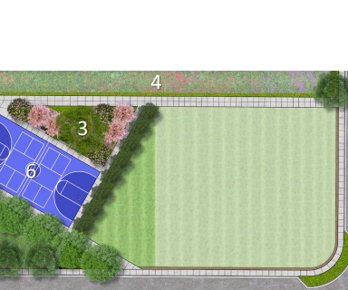
The real story when it comes to River islands is not the fact that it will contain 11,000 plus housing units and is designed to maximize interactions in neighborhoods through a variety of good planning practices. It is what you don’t see for the most part or improvements you might take for granted.
One developer, large parcel
allowed holistic approach
A holistic approach — that includes everything from moisture sensors in front yard and common area landscaping and launching a public power concern to sell electricity below PG&E rates to expanding habitat for the endangered riparian brush rabbit — was made possible by three things. They were the large mass of relatively flat land, Stewart Tract being surrounded on all sides by water, and Cambay Group being owned by England-based Somerston Holdings that wrote the book on long-term investment and responsible corporate stewardship.
The 4,500 acres were owned by one concern. There were no power transmission lines or gas lines crisscrossing the property. The soil was a far cry from the peat-based soils of most reclaimed islands that leads to subsidence. It was surrounded on four sides by water. It was centrally located to Modesto, Stockton, and Tracy. And perhaps the biggest gem of all, it was adjacent to three freeways — Interstate 5, Interstate 205, and the 120 Bypass.
“You could not find undeveloped land that was next to three freeways anywhere in California,” Dell’Osso recalled.
Buying 4,500 acres primarily used for crop farming by the Reclaimed Island Land Club was as close to a blank development canvas you could get in a location that would in the long-haul justify large upfront investments needed to make the envisioned 11,000-home planned community work.
The biggest was addressing the vexing problem of flood protection that was stymied by state and federal rules that were treating aging levees as natural habitat therefore triggering a lengthy review process with agencies such as the Army Corps of Engineers and the state Water Resources Department.
The solution River Islands advocated was widening the levees while restoring natural habitat that had been altered on the river side when levees were put in place more than 120 years ago.
Super levees provide
rare universal access
After waiting for years to secure the first of a series of permits to widen the levees, Cambay engineers found an end run. That end run — which met all environmental concerns and flood control requirements — was to build a parallel dry levee and then fill in the area between the two levees crating a 300-foot wide super levee.
Since it didn’t touch the original levee environmental issues were minimal. And given River Islands was paying the bill — the initial work exceeded $70 million — waiting on government funding was never a concern.
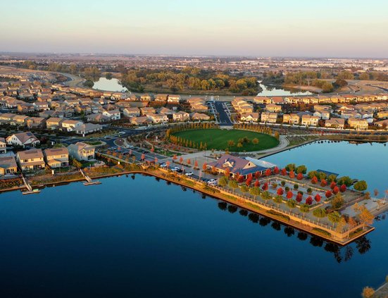
Cambay Group is developing the 18-miles of 300-foort wide levees that will eventually encircle Stewart Tract as open space with an asphalt trail.
It will have universal access whether you are a River islands resident or not. It is also uninterrupted by streets crossing it due to bridges that will cross the entry points to River Islands.
When completed, it will be the most extensive river side access in California that was developed with private money and a huge rarity on the San Joaquin River.
River Islands solution for more flood protection by implementing essentially a 1998 state proposal to reduce flooding by creating a bypass by widening the Paradise Cut is still awaiting approval after 18 years.
Engineers determined expanding the Paradise Cut would reduce flood stages significantly at Mossdale Crossing — 1.8 feet under a 50-year event as well as under a 100-year event such as the 1997 flood that inundated 70 square miles between Manteca and Tracy.
At the same time it would offer habitat and migration territories for juvenile steelhead, salmon and spawning split tail that are driving some water use debates.
And just like the levees, the work — if it is ever approved — will be done on Cambay’s dime.
River Islands takes water
stewardship to next level
How River Islands handles water — the use, collection, and movement — illustrates how it is not a run-of-the-mill development.
River Islands features:
*A system of siphons and pipes that ultimately will connect more than a dozen manmade lakes rely on water hydraulics means water levels during storms, high river flows, and times of drought can be controlled by a single pump house contained in a building that looks like a home. In doing so it minimizes the need for energy.
*It is the first valley community to make it possible to eschew using potable drinking water to irrigate landscaping thanks to tapping into the high water table, river water, and recycled wastewater.
*The system means River Islands will use a third of the water that was pumped from the San Joaquin River when Stewart Tract was entirely farmed. Typically in California urbanization of an acre of farmland sees no net change in water consumption.
*The 300-foot wide super levees provide River Islands unparalleled flood protection and are certified to withstand at least a 200-year flooding event. The bottom width of River Islands levees are close to three times wider than others found in the Delta.
*The lakes now in place and those that we be created in future phases provided 100 percent of the material needed to fashion the levees.
*The 60,000 plus trees and shrubs already in place in common areas around the first 1,600 homes as well as front yards and park grassland are irrigated through the use of moisture sensors assuring water is not wasted.
Each manmade lake was carefully designed to assure water quality, flood and storm run-off control, and even safety.
Swimming is not allowed in any of the lakes. Even so, as a safety measure they are all designed with shelves that go out 20 feet from the water’s edge with a gentle slope that starts at 2 feet in depth.
The high water table and the sandy soil has helped lower the natural high water table somewhat giving that water a place to go. At the same time extensive river rocks lining the sides of the lakes helps naturally filter storm runoff. The manmade lakes are the storm run-off system.
The point where the water from the high water table is removed from the lake system to flow through the irrigation pipes has a series of boxes that assures when reclaimed wastewater is needed to supplement the non-potable water from the high water it is mixed without worry of it flowing into the lake system.
And while the State Water Quality Control Board has no qualms with the quality of the recycled water, it is an example of the redundancy River Island has built into its various water systems.
River Islands is not Cambay Group’s first rodeo. The firm developed the 11,000-home Windemere development in Dougherty Valley on the Interstate 680 corridor in Contra Costa County.
Jarrett has not been part of the Cambay Group for a number of years.
He still owns 100 acres adjacent to River Islands facing Interstate 5 that hopes to develop at some part as retail.
As for the amusement park, for the past 24 years a neighbor of River Islands — Dell’Osso Farms owned by Ron and Susan Dell’Osso — has operated the low key Pumpkin Maze that attracts 160,000 visitors a year.
To contact Dennis Wyatt, email dwyatt@mantecabulletin.com