
Sunday came and went without any worries about levees breaking south of Manteca.
Sunday marked the 23rd anniversary of the first levee failure along the Stanislaus River that sparked the last devastating flood to strike the Manteca area. It ended with 11 breaks along the Stanislaus and San Joaquin rivers that flooded 70 square miles between Manteca and Ripon, damaged 800 homes and buildings, inundated 25,000 acres of agricultural land, forced 2,500 people to flee, required 15,000 head of dairy cattle to be relocated, and caused $100 million in property damage.
Sunday also marked three weeks since the San Joaquin County Board of Supervisors declared a local emergency after Reclamation District 2064 — also known as the River Junction area — reported erosion issues on the north bank of the Stanislaus River south of Manteca and just east of the confluence with the San Joaquin River south of the Airport Way bridge.
The county proclamation allowed RD 2064 to disperse with the environmental review process to make emergency repairs. With the repairs that were completed within a week’s time in coordination with the Department of Water Resources increased rain forecasts or increased reservoir releases upstream, the chance for significant damage had been reduced.
The 1997 flood started with dry skies over Manteca and the temperatures flirting with 70 degrees following nearly a week of unseasonal rain in the high Sierra that melted an above average snowpack. The ensuing runoff prompted dam operators to scramble to create capacity, New Melones Reservoir reported came with a half day of being breeched.
The ensuing heavy flow pounded the Stanislaus River levees. Within a day that heavy flow was joined by substantial above average releases further upstream on the San Joaquin River watershed putting pressure on levees between the confluence of the two rivers and the Mossdale bend. At one point fearing the northern bank levee at Mossdale as well as a dry levee south of Woodward Avenue would fail, the state plugged the undercrossing of Interstate 5 at Louise Avenue and the undercrossing of McKinley Avenue with mounds of dirt covered with tarps. Both the 120 Bypass and Interstate 5 were designed for conversion into emergency levees. Dirt was piled next to the Lathrop Road undercrossing of I-5 with a Caltrans skip loader positioned nearby.
Since 1997 development has occurred west of I-5 in Lathrop while levees protecting the area have been strengthened to a degree. Manteca has allowed nearly 1,000 homes to be built in the area that would have flooded in 1997 if that cross levee had failed.
Manteca and Lathrop are working on a $180 million upgrade to further enhance all of Lathrop north of the river and much of southwest Manteca from flooding.
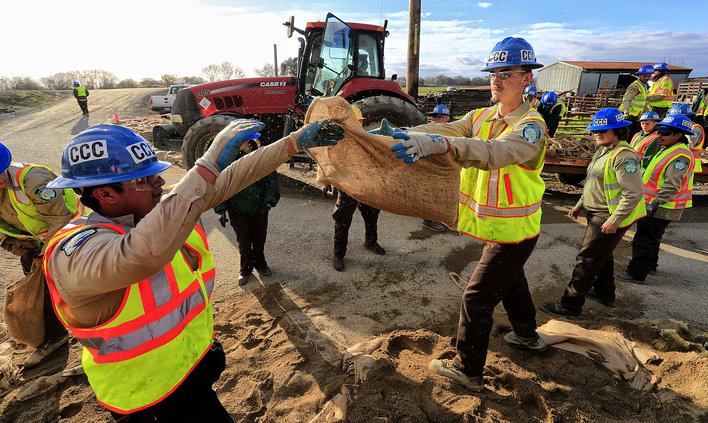
There have been four serious scares with potential levee failures since the 1997 flood. The most serious was in February 2017 when an alert farmer noticed a boil — a precursor to a potential levee failure. Calls to neighbors brought an immediate response of tractors and men to temporarily stop the boil with dirt.
California Conservation Corps crews were dispatched to sandbag the boil and within days emergency levee re-enforcement started.
There have been 11 significant floods since 1929 that started in the River Junction areas south of Manteca where the Stanislaus River joins up with the San Joaquin River.
To contact Dennis Wyatt, email dwyatt@mantecabulletin.com


