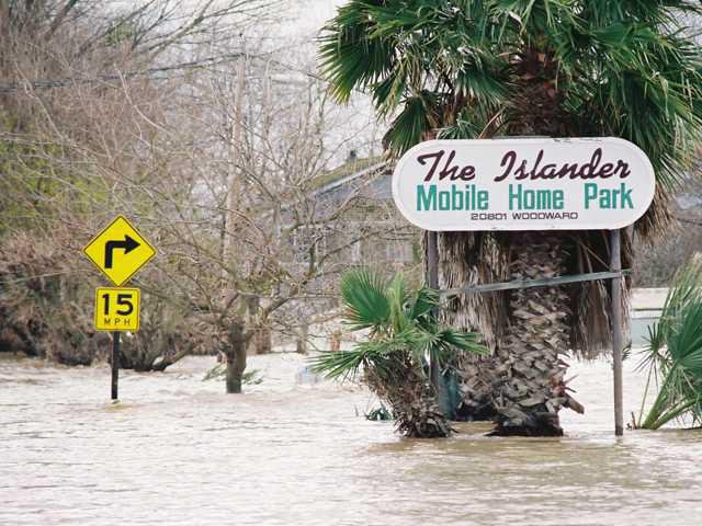
The New Year’s flood of 1997 was like no other seen in Northern California since 1906 when flood records started being recorded. A California Department of Water Resources report called it the “largest” flood in the 90-year period prior to that year’s flooding.
In Manteca and surrounding South San Joaquin County areas, evacuations were the order of the day once the deluge began on New Year’s Day when the levees started losing the battle against the rushing waters from overloaded dams being inundated by an unusual December run-off from rare warm winter rains in the higher snow-covered elevations and were unable to tackle their flood-protection roles.
The rural areas south of Woodward Avenue in Manteca all the way to the confluence of Stanislaus and San Joaquin River, down to the path of San Joaquin that went past Wetherbee Lake and the Islander mobile home park were like ghost towns in their silence. Human activity was limited to dairy farmers moving their animals to higher ground, to residents who dragged their feet hoping for good news finally accepting the inevitable as the waters rose around their homes and along the roads and leaving in cars packed with a few necessities such as clothing, and to law enforcement officers and emergency personnel monitoring the rising flood waters.
It’s been two years short of two decades after that devastating flood which caused $100 million in damages, flooded 70 square miles, force the evacuation of 2,000 people, and permanently changed some governmental policies in terms of building structures in the flooded areas, such as in the Wetherbee residential enclave, and flood insurance.
The newsroom of the Manteca Bulletin was mobilized not just for days but for weeks on end, even beyond the first month of the year as the flood waters stayed on worse than an overstaying unwanted guest. Outside of working hours, this reporter and photographer – like many others in the local and national news media – cruised around the affected areas in south Manteca, Lathrop including the newly incorporated areas at Stewart Tract that is now home to the River Islands at Lathrop development project, chronicling via interviews and photographs what was going on.
Driving around those same areas today, I note some of the visual changes that have occurred since – some more glaring than others. The family-owned poultry business on the corner of South Airport Way and Fig Avenue where I took pictures of two men ferrying boatloads of eggs in knee-high waters, has is no more. Houses at Wetherbee, a residential enclave at the end of Waltham Slough by the San Joaquin River, now look like mansions owing to the fact all houses rebuilt or newly built after the flood had to conform to federal mandates which required the homes to be elevated from the ground by a certain number of feet. The quiet section of Fig Avenue between Oleander Avenue and South Airport Way once again appears like a perfect postcard picture with houses set in a bucolic, rustic setting. During the height of the flood, the one-story house belonging to the Martin family at the time which was inundated for days was visited by Senator Diane Feinstein and then-state senator Mike Machado along with other government officials. They had to wade through muddy waters to view the soggy walls and carpets inside the house. Fortunately for the family, they were covered by insurance. Not so for their less fortunate next-door neighbors who did not have any insurance and whose house was equally devastated by the flood waters.
I have accumulated thousand of photographs taken during the record flood event and its aftermath, both in color and black-and-white films as well as color slides. These are some of those pictures from my personal portfolio.
Flooding marred New Years
Levee failure 17 years ago caused $100M in losses


